The soil particle-size distribution dataset for regional land and climate modelling in ChinaIntroduction | Data characteristics | Data download | Data usage | Data citation | References | Further plan | Help IntroductionParticle-size distribution (PSD) is a basic physical property of soils that affects many important soil attributes. PSD has been widely used for estimating various soil hydraulic properties (Arya and Paris, 1981; Haverkamp and Parlange, 1986; Minasny and McBratney, 2007).The percentage of sand, silt and clay within the soil profile is frequently required to describe the physical processes of soil by land and climate models at regional and global scales (Dickinson et al., 1993; Dai, 2003; Sitch et al., 2003; Gassman et al., 2007). We developed a conterminous China multi-layer soil particle-size distribution (i.e., sand, silt and clay content) dataset with 1km x 1km resolution for regional land modelling use. The source data are the 1:1,000,000 scale soil map of China and 8595 soil profiles from the Second National Soil Survey. The sand, silt and clay maps were derived using the polygon linkage method, which linked soil profiles and map polygons considering distance between them, sample size of profiles, and soil classification information. This data set was developed for use the regional and continental-scale climate, hydrology, crop, and soil erosion modeling. This dataset was derived by the polygon linkage method (Shangguan et al., 2010). In previous studies, the linkage method was usually accomplished by linking soil map units and profiles following the so-called taxotransfer rules (Reynolds et al., 2000; Batjes, 2003; FAO et al., 2009). We called this method as soil type linkage. Soil type linkage gave soil parameter estimates by soil unit for each soil layer, usually with reference to the soil textural class. The variation of soil properties for different map polygons of the same soil type was not considered, which actually existed. In this study, a method of linking soil profiles to individual polygons instead of map units was developed. In order to preserve spatial variation of soil properties as much as possible, two aspects (i.e. sample size of profiles and distance between soil polygons and profiles) other than the soil classification information were taken into account. Figure 1 shows the sand, and clay fraction linked by map polygons. The non-soil map units were assigned zero values for all three fractions. 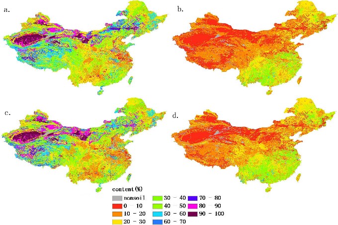 Figure 1: Sand, silt, and clay fractions of China. (a), sand fraction of the topsoil(0-30cm). (b), clay fraction of the topsoil (0-30cm). (c), sand fraction of the subsoil (30-100cm). (d), clay fraction of the subsoil (30-100cm). To evaluate and validate the results of the linkage method, an independent dataset was used. The data were collected from three areas in 2008 and 2009. There were 168, 163 and 58 samples in the Bingxian county of Heilongjian province (3834 km2), Ansai county of Shaanxi province (3607 km2, including parts of the neighbouring counties) and Zitong county of Sichuan province (1435 km2), respectively. For comparison, the soil type linkage was also accomplished by following previous studies in which map units and profiles with the same soil classification information were linked (Reynolds et al., 2000; Batjes, 2003; FAO, et al., 2009). The quality of the derived PSD dataset was assessed based on soil type level of linkage, sample size, and search radius. The linkage level of map polygons is shown in Table 1. The target sample size was achieved, except for 9.2%, 7.8% and 1.2% at the linkage levels of soil family, soil sub-group, and soil group, respectively. Figure 2 shows the counts of different linkage radius between map polygons and soil profiles. The median value was about 146 km and the 75 percentile was about 520 km, which indicates that most linkage happens at the climate zone scale.
Table 1. Numbers of different soil type level of linkage at different soil type level of map polygons.
 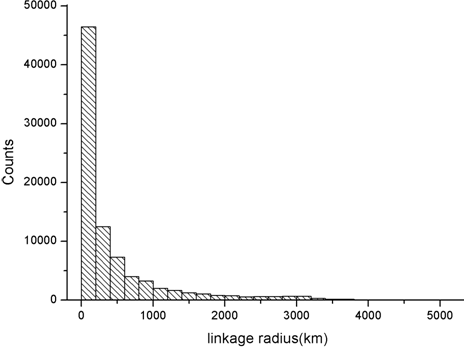
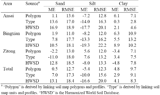
Figure 2. The distribution of linkage radius between the map polygons and soil profiles. Table 2 shows the ME and RMSE of soil fractions for the three datasets: HWSD, the polygon linkage dataset and the type linkage dataset. Overall, polygon linkage gave the most accurate estimation and HWSD gave the least accurate estimation, with the exception of the polygon linkage performing slightly worse than the other two aforementioned datasets on clay content.
Table 2. Accuracy of soil fractions from three datasets in three areas.
 Data characteristics
Data download The dataset can be downloaded in binary floating-point raster (FLT) or TIFF raster format. Data usage
Shangguan, W., Dai, Y., Liu, B., Ye, A. and Yuan, H., 2012. A soil particle-size distribution dataset for regional land and climate modelling in China. Geoderma, 171-172: 85-91.
Batjes, N.H., 2003. A taxotransfer rule-based approach for filling gaps in measured data in primary SOTER databases (ver. 1.1; GEFSOC Project). Technical Report 2003/03, ISRC-World Soil Information, Wageningen. FAO, IIASA, ISRIC, ISS-CAS, JRC, 2009. Harmonized World Soil Database (version1.1). FAO, Rome, Italy and IIASA, Laxenburg, Austia. Reynolds, C. A., Jackson, T. J., Rawls, W. J., 2000. Estimating soil water-holding capacities by linking the Food Agriculture Organization soil map of the world with global pedon databases, continuous pedotransfer functions. Water Resour. Res. 36, 3653-3662. Shangguan, W., Dai, Y., Liu, B., and Ye, A. 2010.A soil particle-size distribution dataset for regional land and climate modelling in China. Geoderma, in revision. Further plan The dataset of other soil properties has been released on this website, including pH, CEC (Cation Exchange Content), soil organic carbon, nitrogen, phosphorus, potassium etc. Help If you have any questions when using PSDC data sets, please email shanggv@hotmail.com. |
 |