Holy Tree on QuShui, Tibet - Photo by Yongjiu Dai

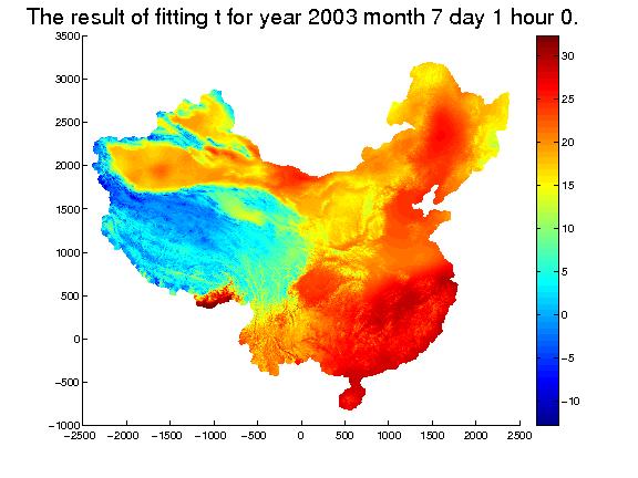
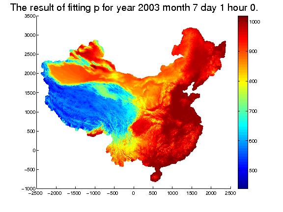
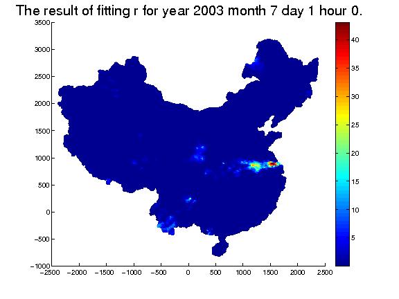
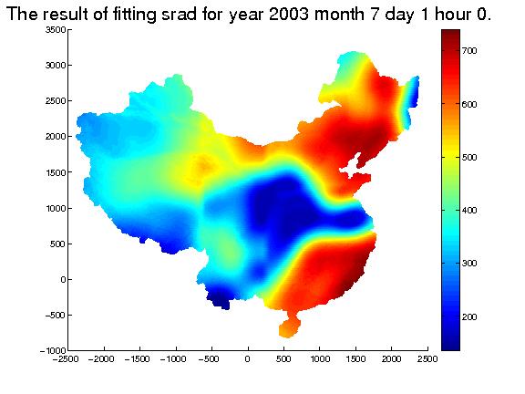
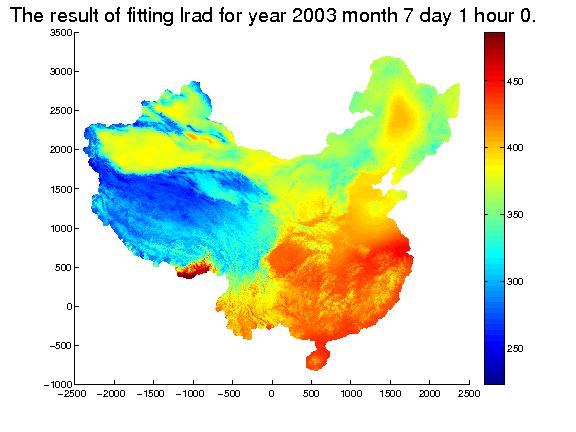
A 53-Year 5x5 km Resolution China Dataset of Meteorological Forcings for Land Surface Modeling

Introduction | Data download | Data citation | Acknowledgement | Help

--- Please DO NOT USE like Thunder with too many threads!!! ---
Introduction

The dataset of land surface forcing field for China Mainland, in the period of 1958 to 2010*, is provided.

The dataset consists of 7 components: near-surface air temperature, near surface air pressure, near surface relative humility, wind speed, rainfall rate, downward longwave radiation and downward shortwave radiation.

The temporal-spatial resolution of this dataset is 3hr and 5km.

The documentation for this dataset can be downloaded here, including readme, geographic_information for the products, technical_details for the method we use and the analysis of the results, and format-conversion program by Visual FORTRAN 6.5.

*Because of the limitation of the storage of our current system, we only provide the data for 2000 to 2010, and we will upload the rest as soon as possible.

Data download

The dataset in compressed format can be downloaded in the following table.

Temperature

Variable Name

Physical Meaning

Unit

Format

Scaling factor

Figure

Data

t

Instantaneous 2-meter
air temperature.

°C

short[int]

100

fig

1958 1959 1960 1961 1962 1963 1964 1965 1966 1967 1968 1969 1970 1971 1972 1973 1974 1975 1976 1977 1978 1979 1980 1981 1982 1983 1984 1985 1986 1987 1988 1989 1990 1991 1992 1993 1994 1995 1996 1997 1998 1999 2000 2001 2002 2003 2004 2005 2006 2007 2008 2009 2010


Pressure

Variable Name

Physical Meaning

Unit

Format

Scaling factor

Figure

Data

p

Instantaneous near surface air pressure.

hPa

short[int]

10

fig

1958 1959 1960 1961 1962 1963 1964 1965 1966 1967 1968 1969 1970 1971 1972 1973 1974 1975 1976 1977 1978 1979 1980 1981 1982 1983 1984 1985 1986 1987 1988 1989 1990 1991 1992 1993 1994 1995 1996 1997 1998 1999 2000 2001 2002 2003 2004 2005 2006 2007 2008 2009 2010


Relative Humility

Variable Name

Physical Meaning

Unit

Format

Scaling factor

Figure

Data

rh

Instantaneous 2-meter
relative humility.

%

short[int]

100

fig

1958 1959 1960 1961 1962 1963 1964 1965 1966 1967 1968 1969 1970 1971 1972 1973 1974 1975 1976 1977 1978 1979 1980 1981 1982 1983 1984 1985 1986 1987 1988 1989 1990 1991 1992 1993 1994 1995 1996 1997 1998 1999 2000 2001 2002 2003 2004 2005 2006 2007 2008 2009 2010


Wind Speed

Variable Name

Physical Meaning

Unit

Format

Scaling factor

Figure

Data

w

Instantaneous 10-meter
wind speed

m/s

short[int]

100

fig

1958 1959 1960 1961 1962 1963 1964 1965 1966 1967 1968 1969 1970 1971 1972 1973 1974 1975 1976 1977 1978 1979 1980 1981 1982 1983 1984 1985 1986 1987 1988 1989 1990 1991 1992 1993 1994 1995 1996 1997 1998 1999 2000 2001 2002 2003 2004 2005 2006 2007 2008 2009 2010


Rainfall Rate

Variable Name

Physical Meaning

Unit

Format

Scaling factor

Figure

Data

r

3-hourly amount ( from -3hr to 0hr)
rainfall rate.

mm/3hr

short[int]

100

fig

1958 1959 1960 1961 1962 1963 1964 1965 1966 1967 1968 1969 1970 1971 1972 1973 1974 1975 1976 1977 1978 1979 1980 1981 1982 1983 1984 1985 1986 1987 1988 1989 1990 1991 1992 1993 1994 1995 1996 1997new 1998new 1999new 2000new 2001new 2002new 2003new 2004new 2005new 2006new 2007new 2008new 2009new 2010new


Downward Shortwave Radiation

Variable Name

Physical Meaning

Unit

Format

Scaling factor

Figure

Data

srad

3-hourly mean (from -1.5hr to 1.5hr)
surface shortwave radiation

W/m2

short[int]

10

fig

1958 1959 1960 1961 1962 1963 1964 1965 1966 1967 1968 1969 1970 1971 1972 1973 1974 1975 1976 1977 1978 1979 1980 1981 1982 1983 1984 1985 1986 1987 1988 1989 1990 1991 1992 1993 1994 1995 1996 1997 1998 1999 2000 2001 2002 2003 2004 2005 2006 2007 2008 2009 2010


Downward Longwave Radiation

Variable Name

Physical Meaning

Unit

Format

Scaling factor

Figure

Data

lrad

3-hourly mean (from -1.5hr to 1.5hr)
surface longwave radiation

W/m2

short[int]

10

fig

1958 1959 1960 1961 1962 1963 1964 1965 1966 1967 1968 1969 1970 1971 1972 1973 1974 1975 1976 1977 1978 1979 1980 1981 1982 1983 1984 1985 1986 1987 1988 1989 1990 1991 1992 1993 1994 1995 1996 1997 1998 1999 2000 2001 2002 2003 2004 2005 2006 2007 2008 2009 2010


Data citation

Li, T., X. Zheng, C. Yang, Y. Dai, Z. Chen, S. Zhang, G. Wu, Z. Wang, and C. Huang, 2013: Using Spline and Residual Kriging to Merge Observational and Reanalysis Data for Mapping near Surface Air Temperature, Pressure and Humidity in China Mainland. Journal of Applied Meteorology and Climatology.

Huang, C., X. Zheng, A. Tait, Y. Dai, Z. Chen, T.Li and Z. Wang, 2013: On using smoothing spline and residual correction to fuse rain gauge observations and remote sensing data. Journal of Hydrology.

Acknowledgement

This work was supported by the Natural Science Foundation of China (under grants 40875062, and 40975062), the R&D Special Fund for Nonprofit Industry (Meteorology, GYHY201206013, and GYHY201206008) and National high-tech R&D Program of China (2009AA122104).

Help

If you have any questions when using the forcing field dataset, please email wangzhonglei1234@mail.bnu.edu.cn.